
River Roads to St. Regis
Updated: Mar 17
My campsite for the night beside the St. Joe River was one of the finest I'd found. Tucked beneath the trees, I was nestled among the blanket of snow and sapphire blue river, making for a tranquil scene in a cozy winter sort of way. Unfortunately, my time there was short since I still had to climb a good bit of elevation through wet snow to get to St. Regis, MT. After enjoying the morning rays for a few moments along with a light breakfast, I began packing up camp before getting moving so that I could make it over the pass with plenty of daylight to spare.
Back on the road, which was oddly paved now, I snaked along the river for awhile longer. Sheer short rock bluffs appeared on the drivers side after a little bit, creating a small plateau with pines on its top. The bluffs were a dynamic feature of the landscape, bordered with jagged, broken edges that deposited loose bits of rock all along the shoulder, crumbling day in and day out. Further down, I noticed that there were some bigger pieces of rock in the road here and there, no longer mere pebbles. A few hundred yards beyond that, there were a couple of chunks of the bluff itself, actual boulders, right in the middle of the road! The sight immediately made me glad that I had stopped where I did the night before, thereby avoiding discovery of the rock road hazards in the pitch black of night. Pulling over to the side of the road, I managed to sling the first out of the way, with the second being a good bit tougher. It had to be every bit of 80 pounds or more and awkwardly shaped at that. I was able to teeter it back and forth somehow, moving it in a generally forward direction a few inches at a time. This eventually allowed it to rumble a few feet to the side, safely off the road and away from any other passing drivers.
As I got back into my truck, I heard a buzz and glanced at my phone in its holder on the dash. It was a message notification, meaning I had a bit of cell service. Immediately, I tapped the weather app and typed in St. Regis. After a ten-minute wait along the road, the app finally finished loading, showing me the forecast for the next few days. The weather looked clear with some sun, and more importantly, the temperature was supposed to be a few degrees above freezing, meaning the snow would be heavy but also melting and shrinking. Based on the relatively light snow cover I was seeing at 3400 feet where I was, I was optimistic that it wouldn't be too deep at the 5800 foot elevation of the pass itself. A foot of snow I could handle, multiple feet would pose issues, but it was still early in the season and I could always turn back. On the map I'd seen that there was a convergence of forest roads near the summit, meaning there was room to turn around if needed.

Confident that my plan and path ahead were sound, I pulled off the shoulder and continued down the forest road for another mile or so until I came around a bend where the river veered due south and a large, vast meadow opened up to the north. Even though it was all covered with winter's cloak, I could imagine the vast meadow teeming with vibrant wildflowers and grasses swaying in a light summer breeze during the warmer months of the year. The only sounds around were the chirping of a few birds and the water passing by, riding over the smooth river stones, continuing to carve its path through the wilderness.
At the bend, there was a bridge spanning the river, along with a few signs. One of them mentioned Red Ives Station and showed an arrow pointing down the waterway. Having no idea where it led but curious who Red Ives was, I decided to take the bait and follow the sign to the station, also intrigued to see what was out there in the middle of nowhere. The path quickly turned to gravel, narrowing along the side of the river. One could tell that this road was a lot less traveled, and I soon saw why. The surface became a ragged washboard at a few points that rhythmically jostled the whole truck and camper around unless I kept it at just the right speed, which only brought slight improvement. A handful of hanging branches and tree trunks gone awry kept my eyes alert, making for a long, dodgy 10-mile or so drive back to the outpost.
Once I arrived, I came around the bend to see a large meadow opening up and spreading out across the river, continuing on down the little valley. The river was spanned yet again with an old iron bridge, and opposite it was Red Ives Ranger Station itself, tucked in right there beside the road. As I glanced around, I saw something move in the distance down the meadow, and then a darker shape. It was two horses—a palomino and a bay—hanging out all the way out there. I pulled into the cabin complex in front of a long garage building and swung my legs out of the truck. The mountain air was cool going into my lungs, yet the sun was shining and the temperature had warmed considerably. I was glad I had taken this side trip and would now have the chance to explore on my feet a bit and enjoy the secluded Idaho valley.
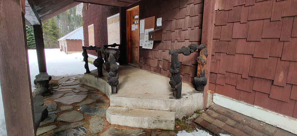
The station was just a few dozen yards away on the edge of the pines, all boarded up for the winter, along with the other outbuildings. It had been built by the Civilian Conservation Corps in the 1930s along with most of the outbuildings. It was a bit larger than others I'd seen, with a sizable second story and a large footprint, including the porch pictured below. The knotted, gnarled railings and posts were a unique touch, and I wondered if they were a part of the grand design or added by some creative soul who happened to be there when it was built. Or perhaps the whole porch itself was a summer project for one of the summer crews of rangers stationed out there.
Walking along the edge of the woods between the station and trees, I found another smaller cabin tucked a bit closer in, with a shed of its own. It had a small, covered, raised porch on the front, more integrated into the structure itself than the porch of the station; this house was just large enough to contain a few rooms. It too was boarded up for the winter, although I later found out it is also available for rent in the summer months for anyone who wants to venture down the lonely road. Wandering back to the driveway of the station itself, I stared out across the river. It was filled with willow thickets and long, wilted grass in yellow-brown masses poking out from beneath the snow. The horses roamed about and seemed as happy as could be on a clear day. I was hoping to see some elk or deer grazing down the valley, but perhaps they felt it was too exposed at midday.
Gazing at the bridge itself now, I wandered across the road and up onto its wide wooden planks. It wasn't huge, just a single lane across and approximately 30 feet long, with the aforementioned planks making up the floor, flanked by the rusty trusses rising up waist high on both sides. There was a pipe gate on the opposite bank to keep the horses from crossing, but I could see a gate for a person next to it with hiking signs, making me wonder about a trail. I was tempted to wander down and see, but I hadn't downloaded the hiking maps for that area, and the snow appeared to get deeper and deeper. The horses were staring intently in my direction now, wondering who this newcomer was to their slice of rocky mountain seclusion.
Image courtesy of the University of Idaho Library
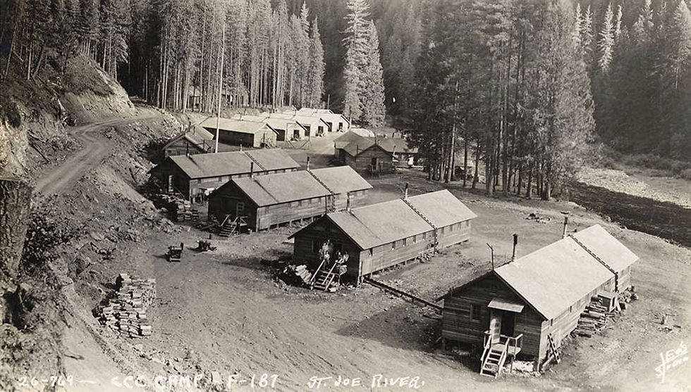
Civilian Conservation Corps Camp along the St. Joe River circa 1936
Turning around, I spied a small square rooftop among the grasses along the top of the riverbank, with a small building below perched midway between the road and the river itself, mostly hidden from view when standing on the roadway behind it. I walked over to it and approached it from that angle, finding a short stairway leading to a single locked door. There were no windows, just a porch wrapping partially around. As I leaned over a railing above the swiftly cavitating river water, I spied a water wheel and surmised that the structure must've been a sort of power station that generated electricity for the ranger station.
Hundreds, if not thousands, of ranger stations across the west were built by the Civilian Conservation Corps in the 1930s. They also helped to create over 700 state parks and planted over 3.5 billion trees over the span of the program from 1933 to 1942. The program employed over 3 million American men during this time, stationed in thousands of remote camps across the nation, with a large majority in the west. They worked on all manner of projects, including roadbuilding, fighting forest fires, soil erosion projects, the construction of water-storage basins, wildlife refuges, trails, and shelters for animals and humans alike. It's hard to imagine, but without this period in American history, many parts of the West would've remained much more isolated and remote than they are today. Many of the hiking trails and campgrounds that millions of Americans enjoy today might not have existed. These weekend escapes for people driving out of the cities and suburbia would be unavailable for use to rest and recharge in the wilds of Mother Nature.
Image Courtesy of Getty Images and https://www.history.com/topics/great-depression/civilian-conservation-corps
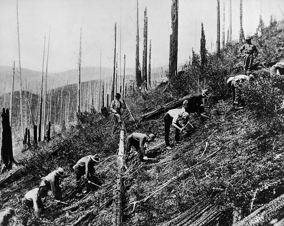
Pictured above are men of the CCC's Reforestation Army clearing a burned mountainside in the St. Joe National Forest, in preparation for the planting of seedlings.
In the last 10 miles on the road to the station alone, I had passed three developed campsites like the one I'd stayed at along the river. The amount of forest roads throughout the west as a whole is impressive in many regions. Although there are also plenty of wilderness areas, which don't have any roads at all, in order to keep the land as original as possible. One well-known wilderness area was nearby to the south, the Frank Church-River of No Return Wilderness, the largest federally managed wilderness in the lower 48 states at over 2.3 million acres in size.
Walking back from the power hut, content with my midday jaunt, I took a last look around while heading towards the truck. A few moments later, I was rolling north to meet back up with Gold Creek Road, keeping an eye out for the few height hazards I had seen on the way in. I encountered no other vehicles or boulders the whole way and was soon back at the fork in the road. Turning northeast now, I was bound for the pass just under Flattop Mountain on the Montana border. The first six miles or so of road from there were surprisingly straight and made for a gradual climb in elevation, with the route being mostly clear of snow beyond random patches. I had passed signs saying the road was not maintained in winter, but I guessed that this early in the season someone was still plowing it for hunters and others using the pass until true winter rolled in.
I was shrouded from the modern world in those mountains, with the pines standing strong and tall like an army in the forest, the sun overhead, and the wind streaming past. On account of the good conditions, before an hour had gone by, I was just below the mountaintop crossing, and that is where things changed a bit. Slush scattered the road, with ice becoming more prevalent as I climbed through a couple of nasty switchbacks that weaved up the steeper parts. The pines remained thick here, around 6000 feet, and as I came to the very top of the pass, they fell away, and before me was a very open swath of country. With the sun bathing my back, I glimpsed back into Montana, towards St. Regis nestled in the valley below.

I remained at the top for a few moments, glad to have made it up relatively easily. I could see from there that the snow got thicker like a cake at parts on the eastern slope of the mountains. I figured at least the day was warm enough to melt the snow, and gravity would also help me downhill a bit. After failing to take any photos, I continued on down, with the road widening out, which I was thankful for given the snow. With four wheel drive and all the weight, the truck managed to stay pretty planted and maintained traction most of the time. I soon encountered one sharp switchback and then a huge dogleg U-turn a couple miles past that. I had to climb up and down a few small ridges, hoping that the snow wasn't packing into my all-terrain tires and turning them into slicks. Maintaining my momentum helped me roll through, and soon enough, the snowpack got thinner and thinner.
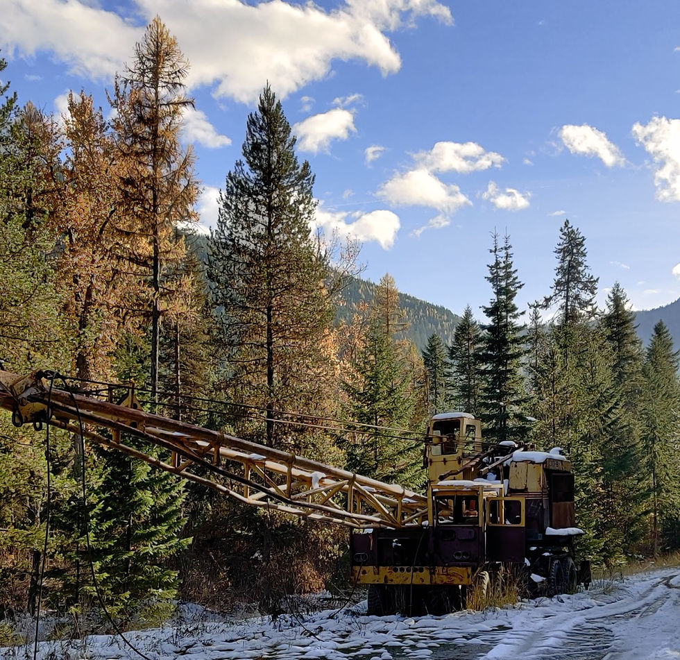
Once I was almost to the valley floor, I spotted some dated equipment that was scattered along the road. Old machinery and infrastructure rusting away back into nature is one of my favorite things about the west. So often out there, machines and tools from the past have stayed behind, standing as reminders, keeping people just a bit more connected to their past. Here, they were steel cable-raising relics from the logging days, left behind in the woods, suspended in a perpetual icy slumber guarding the gates to the wilds.
Sources:
Editors, History.com. “Civilian Conservation Corps.” History.Com, A&E Television Networks, www.history.com/topics/great-depression/civilian-conservation-corps. Accessed 02 Feb. 2024.

Comments